Pan-Arctic Full Outlook: Brief Update
OVERVIEW OF RESULTS
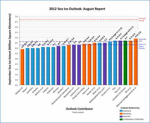
With 23 (thank you!) responses for the Pan-Arctic Outlook (plus 5 regional Outlook contributions), the August Sea Ice Outlook projects a September 2012 arctic sea extent median value of 4.3 million square kilometers, with a range of 3.9–4.9 (Figure 1). The quartiles for August are 4.1 and 4.6 million square kilometers, a narrow range given that the uncertainty of individual estimates is on the order of 0.5 million square kilometers. The consensus is for continued low values of September 2012 sea ice extent. The August Outlook median is lower by 0.3 million square kilometers than the July estimate, consistent with low summer 2012 observed values. According to the National Snow and Ice Data Center (NSIDC), the arctic sea ice extent for July 2012 was the second lowest in the satellite record behind 2011; the ice extent recorded for August 1st of 6.5 million square kilometers is the lowest in the satellite record. Twelve of the contributions give a value equal to or lower than the 2007 record minimum (monthly average) extent of 4.3 million square kilometers.
Individual responses are based on a range of methods: statistical, numerical models, comparison with previous rates of sea ice loss, composites of several approaches, estimates based on various non-sea ice datasets and trends, and subjective information.
Again, we are comparing these Outlook values to the September average sea ice extent as provided by NSIDC. NSIDC is not the only data source for ice extent; their estimate is based on a long-term time series and we use their value as an operational definition.

Download High Resolution Version of Figure 1.
DEVELOPMENT OF SUMMER 2012 SEA ICE CONDITIONS AND RECENT WEATHER
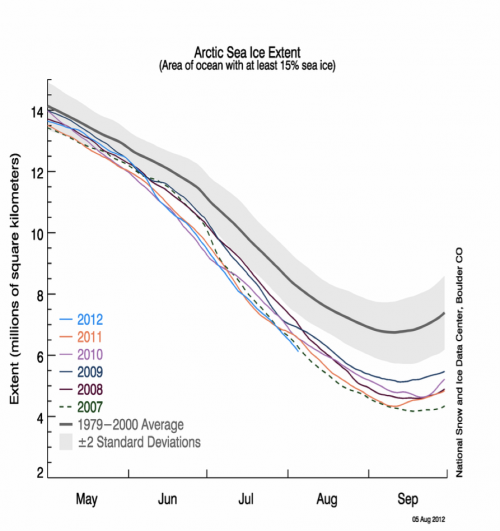
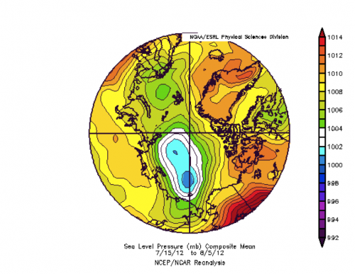
The NSIDC time history for 2012 compared with previous years is shown in Figure 2. As noted in previous Sea Ice Outlook reports this year, sea ice extent in May started higher than several previous years and there were indications of increased thickness on the North American side. But late May and the first half of June had the Arctic Dipole (AD) Pressure pattern that is favorable for ice loss, resulting in a record trend in sea ice loss. At the end of June the AD was replaced by low sea level pressure. At this point, the sea ice loss showed more of a historical loss trend, but because of the low June value it has remained below the previous lowest value from 2007. The sea level pressure field for the second half of July and early August (Figure 3) shows that the low pressure centered along the dateline has persisted for most of the summer. This a a fairly typical historical summer pattern, if perhaps a bit stronger.


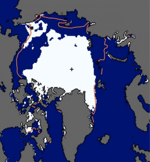
The pattern in Figure 3 is favorable for sea ice loss near the Canadian side of the North Pole and in the Kara Sea, but not in the Pacific Arctic as in previous summers. The recent NSIDC sea ice chart from 9 August (Figure 4) shows major open water areas in the eastern Beaufort Sea, East Siberian Sea, and Kara Sea, and a strip of sea ice continuing in the Chukchi Sea. These areas opened up quickly in the last few weeks. Also note the open areas within the ice pack.
Except for early June, the weather was not particularly favorable for sea ice loss in summer 2012 as it was in 2007 and some other recent years. Given the lack of meteorological support and several indications that the sea ice was rather thin, we note that thermodynamic melting of thin, mobile sea ice is now a dominant process, justifying the low sea ice predictions in the Sea Ice Outlook.

KEY STATEMENTS FROM INDIVIDUAL OUTLOOKS
Wang et al, 3.9 +/-0.3, Model
The outlook is based on a CFSv2 ensemble of 40 members initialized from Jul 27-Aug 5, 2012. The model’s systematic bias, forecast RMS errors, and anomaly correlation skill are estimated based on its historical forecasts for 1982-2011. The CFSv2 has shown long-term decrease of sea ice extent during the past 3 decades, as in the observation. The CFSv2 was also found to have some skill in predicting year to year variability at seasonal time scales.
Arbetter, 4.0, n/a, Statistical (updated 13 August)
Using conditions from week 30 of 2012 (ie August 1, 2012), a revised minimum Arctic sea ice extent of 4.03 million km2 is projected for the week of September 7, 2012. This is substantially lower than the earlier estimates, reflecting both lower than average sea ice extent used as initial conditions this summer and a persistent downward trend in sea ice extent over the past decade (and longer). The output continues to suggest 2012 will be at or below the previous record minimum September ice extent, recorded in 2007 and repeated in 2011.
Klazes, 4.0 +/- 0.7, Statistical
Extent is predicted by first estimating minimum ice volume for September. Using a linear minimum ice volume-extent model the extent is calculated. Only data up to 2011 is used. The method is statistical, based on mean September ice extent and minimum September ice volume (PIOMAS, Zhang and Rothrock, 2003).
Hamilton, 4.0 +/- 0.3, Statistical
A simple regression model for NSIDC mean September extent as a function of mean daily sea ice area from August 1 to 5, 2012 (and a quadratic function of time) predicts a mean September 2012 extent of 4.02 million km2, with a confidence interval of plus or minus .32. This supersedes an earlier year-in-advance prediction based on a Gompertz (asymmetrical S curve) model that used data only through September 2011.
Beitsch et al, 4.1 +/- 0.1, Statistical
The KlimaCampus's outlook is based on statistical analysis of satellite derived sea ice area.
We introduced the following method: use of near-real-time (SSMI/S) sea ice concentration data combined with long data sets (SSM/I: 1992{2011), a time-domain _lter that reduces observational noise, and a space-domain selection that neglects the outer seasonal ice zones. The daily estimate of the September extent, the anomaly of the current day and a time series of daily estimates since May 2012 can be found on our ftp-server: ftp://ftp-projects.zmaw.de/seaice/prediction/2012/
Folkerts, 4.1 ± 0.2, Statistical
A variety of publicly available monthly data from 1978 forward (including area, extent, volume, regional extent, NCEP Reanalysis Data, and various climate indices) was collected. For each year, monthly data up to 24 months before the September minimum extent was organized and correlated with the minimum extent. Multiple regression analysis was also performed on a variety of combinations of these explanatory variables, seeking sets of data that correlate well with September extent, while trying to avoid overfitting. In addiction, analysis was also performed using the annual change in extent as the dependent variable (which, together with the extent the previous September, also allows predictions of the upcoming minimum).
Andersen, 4.1, n/a, Statistical
Same as last month.
Morison, 4.2, n/a, Heuristic
Same as last month.
Randles, 4.2, ± 0.7, Statistical
I use an average of two methods. One is as used in my previous submissions this year of a linear regression to predict the expected residual from a gompertz fit of September Extent using the residual from a gompertz fit of Cryosphere Today area. The other method is to calculate a weighted average of Cryosphere Today area and NSIDC Extent giving 1.5 weight to area. The difference between this and the NSIDC September average extent is calculated and estimated with a linear trend.
Naval Research Laboratory, 4.3 +/- 0.6, Model
The Arctic Cap Nowcast Forecast System (ACNFS) was run in forward model mode, without assimilation, initialized with a July 1, 2012 analysis, for nine simulations using archived Navy atmospheric forcing fields from 2003-2011. The mean ice extent in September, averaged across all ensemble members, is our projected ice extent. The standard deviation across the ensemble mean ice extents is an estimate of the uncertainty of our projection given we do not know the atmospheric conditions that will occur this summer. Please note, this is a developmental model that has not been fully validated in non-assimilative mode, but the assimilative system has been validated to provide an accurate ice forecast [Posey et al. 2010].
Netweather.tv, 4.3, n/a, Heuristic
The prediction method was based on a poll of Netweather.tv forum members. The question was “What do you think the MEAN September sea ice extent will be?” The mean (4,338,095km2) of the…votes was rounded to the closest 100,000 and used to form the prediction.
Lukovich et al, 4.3, n/a, Heuristic
It is hypothesized that the 2012 fall sea ice extent will attain values comparable to those of 2011 based on a heuristic assessment of sea ice and surface atmospheric dynamics, with regional losses governed by local wind and ice conditions.
Zhang and Lindsay, 4.4, +/- 0.4, Model
These results are obtained from a numerical ensemble seasonal forecasting system. The forecasting system is based on a synthesis of a model, the NCEP/NCAR reanalysis data, and satellite observations of ice concentration and sea surface temperature. The model is the Pan-Arctic Ice-Ocean Modeling and Assimilation System (PIOMAS, Zhang and Rothrock, 2003). The ensemble consists of seven members each of which uses a unique set of NCEP/NCAR atmospheric forcing fields from recent years, representing recent climate, such that ensemble member 1 uses 2005 NCEP/NCAR forcing, member 2 uses 2006 forcing …, and member 7 uses 2011 forcing…In addition, the recently available IceBridge and helicopter-based electromagnetic (HEM) ice thickness quicklook data are assimilated into the initial 12-category sea ice thickness distribution fields in order to improve the initial conditions for the predictions.
Keen et al (Met Office), 4.4, +/-0.9, Model
Same as last month.
Kauker et al, 4.5, +/- 0.4, Model
Sea ice-ocean model ensemble run - For a more detailed description we refer to our July report. The ensemble model experiments for the August outlook all start from the same initial conditions on July 30th 2012. The simulated daily ice extent for all 20 realizations of the ensemble is shown in Figure 1 from the initialization until end of September. Note that August and September atmospheric conditions similar to 2007 would result in a September minimum of 3.6 million km2 (thick black line in Figure 1). Atmospheric forcing similar to the years 2008 and 2010 would give a September mean of about 4.0 million km2 .The mean September value of the ensemble mean is 4.46 million kmÇ (bias corrected). The standard deviation of the ensemble is 0.38 million km2 which we provide as uncertainty estimate of the prediction.
Meier et al, 4.5, +/-0.3, Statistical
This statistical method uses previous years’ daily extent change rates from August 1 through September 30 to calculate projected daily extents starting from July 31. The September daily extents are averaged to calculate the monthly extent. Rates from recent years are more likely to occur because of the change in ice cover. Thus, the official projection is based on the rates for 2002-2011, yielding a September 2012 average of 4.47 million square kilometers; the range however is still quite large with a standard deviation of 335,000 square kilometers. Using all years (1979-2011) yields a slightly higher estimate of 4.66 million square kilometers, but a similar range of 337,000 square kilometers. Five out of the 33 scenarios (using rates from 1979, 1999, 2004, 2007 and 2008) would yield a new record minimum September extent. This suggests the chance for a record low this year is ~15%, though this probably underestimates the probability because recent years have tended to follow faster decline rates.
WattsUpWithThat.com, 4.5, n/a, Heuristic
Reader poll.
Stroeve et al, 4.6, range 4.1-5.2, Statistical
Same as last month.
Tivy, 4.7, +/-0.5, Statistical
A persistence forecast based on anomalies in July extent where the mean period is defined as the average of the previous five years. Persistence is a benchmark for more sophisticated techniques.
Kay et al, 4.7, range 4.0-5.7, Heuristic
An informal pool of 23 climate scientists on June 1, 2012 estimates that the September 2012 Arctic sea ice extent will be 4.68 million sq. km. (stdev. 0.32, min. 4.00, max. 5.70). In 2008, 2009, and 2011, our informal pool estimates of the mean September ice extent were within 0.10 million sq. km. of the corresponding observed value, making our informal method competitive with more sophisticated prediction efforts.
Canadian Ice Service, 4.7, n/a, Multiple Methods
As with CIS contributions in June 2009, 2010 and 2011, the 2012 forecast was derived using a combination of three methods: 1) a qualitative heuristic method based on observed end-of-winter Arctic ice thicknesses and extents, as well as an examination of Surface Air Temperature (SAT), Sea Level Pressure (SLP) and vector wind anomaly patterns and trends; 2) an experimental Optimal Filtering Based (OFB) Model which uses an optimal linear data filter to extrapolate NSIDC’s September Arctic Ice Extent time series into the future; and 3) an experimental Multiple Linear Regression (MLR) prediction system that tests ocean, atmosphere and sea ice predictors.
Wu et al, 4.7, +/-0.3, Model
Same as last month.
Blanchard-Wrigglesworth et al, 4.9, +/-0.6, Model
Same as last month.
| Attachment | Size |
|---|---|
| Andersen93.47 KB | 93.47 KB |
| Arbetter225.61 KB | 225.61 KB |
| Beitsch et al.3.04 MB | 3.04 MB |
| Blanchard-Wrigglesworth et al.2.4 MB | 2.4 MB |
| Canadian Ice Service116.13 KB | 116.13 KB |
| Folkerts32.5 KB | 32.5 KB |
| Hamilton345.17 KB | 345.17 KB |
| Kauker et al.167.67 KB | 167.67 KB |
| Kay et al.28.52 KB | 28.52 KB |
| Keen et al.352.05 KB | 352.05 KB |
| Klazes297.65 KB | 297.65 KB |
| Lukovich et al.3.12 MB | 3.12 MB |
| Meier et al.403.07 KB | 403.07 KB |
| Morison34.1 KB | 34.1 KB |
| Naval Research Laboratory575.54 KB | 575.54 KB |
| Netweather.com65.45 KB | 65.45 KB |
| Randles61.07 KB | 61.07 KB |
| Stroeve et al.576.72 KB | 576.72 KB |
| Tivy76.79 KB | 76.79 KB |
| Wang et al.133.97 KB | 133.97 KB |
| WattsUpWithThat.com32.63 KB | 32.63 KB |
| Wu et al.38.82 KB | 38.82 KB |
| Zhang and Lindsay450.55 KB | 450.55 KB |
| Attachment | Size |
|---|---|
| Gerland231.31 KB | 231.31 KB |
| Gudmandsen50.74 KB | 50.74 KB |
| Howell1.36 MB | 1.36 MB |
| Tivy1.73 MB | 1.73 MB |
| Zhang and Lindsay450.51 KB | 450.51 KB |


